Using Google Earth to scout lakes and rivers is nothing new, but this hidden gem in the app is not known or utilized by many bass fishermen.
Google Earth has been a handy tool to scout waters that bass anglers want to fish. The app has long had a function within it that many users did not know was there. The Historical Imagery slider allows anglers to see their favorite bass waters over time. It can reveal important changes and seasonal variables that are key pieces of information to find more bass.
In this article, I will discuss the Historical Imagery portion of Google and how this data is helpful for learning your favorite waters.
Aerial Images
Any time that bass anglers can get a birds-eye-view of lakes and rivers a wealth of information can be found.
A few minutes looking at satellite images can yield places that hours of scanning with side-imaging electronics may not ever locate.
Shore anglers can use Google Earth to pick apart key targets that they may have never seen without being in a boat.
Google Earth is nothing new, but the application has a long-standing feature most anglers have not used or did not even know about.
Where to Find the Historical Imagery
When the Google Earth application is first opened users see an image showing the entire planet.
The search box in the upper-left corner allows for specific locations to be typed in. The app then zooms in and centers the target area on the screen.
The right side of the screen has sliders, a compass, and other viewing controls to allow bass anglers to position the screen in the best location to figure out where they may or may not find good bass cover and structure.
Look Carefully
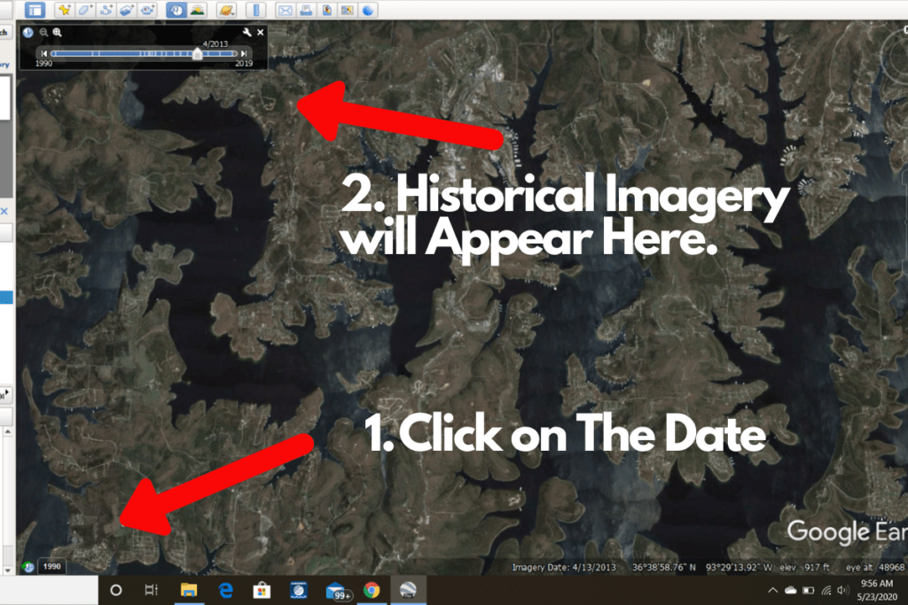
As a user hits the plus button to get a closer photo, be sure to look in the lower-left corner.
Once the image is zoomed in far enough, there will be a small black box that has a date in it.
When a user clicks on that box, an additional slider will appear at the top of the screen. This slider will allow users to scroll back-and-forth to see the different images captured by satellites of the area.
Some images are clear and quite detailed and others are less than ideal, but on most of the lakes and rivers I have researched, there is enough information to help find new places where bass may be hiding.
What Should Anglers be Focused On?
This varies depending on the type of water.
Impoundments that are used for flood control and river systems will show a much different historical pattern than those lakes and ponds that have little fluctuation throughout the year.
Flood Conditions
When the water rises it follows the low spots.
While sitting on a major reservoir in a flood stage it is difficult to grasp the full picture of what is happening.
Where are there new underwater points? Where are the deeper pockets in the flooded shoreline? What is the travel route bass will use to escape the floodwater once it starts to recede?
By using the Historical Imagery and Google Earth, a bass angler can see the new shoreline created if a satellite happened to snap a photo during a high water situation.
It is fascinating to scan the lake we thought we knew and see what actually happens. Anglers can utilize this info to make a plan the next time their favorite impoundment is on the rise.
Vegetation Changes
If the waters that you fish have decent visibility most of the year, following the vegetation change is astonishing.
On the waters I fish the most often, it was crystal clear when the weeds started to grow in the spring, what their maximum summer expanse was, and then how far into the fall/early winter they lasted before the lake bed was mostly barren.
It was also clear which weedbeds were the first to grow each spring and which were the last to die-off each fall.
This simple information will help me know where to start looking at those critical times of the year when big bass are most likely to be shallow.
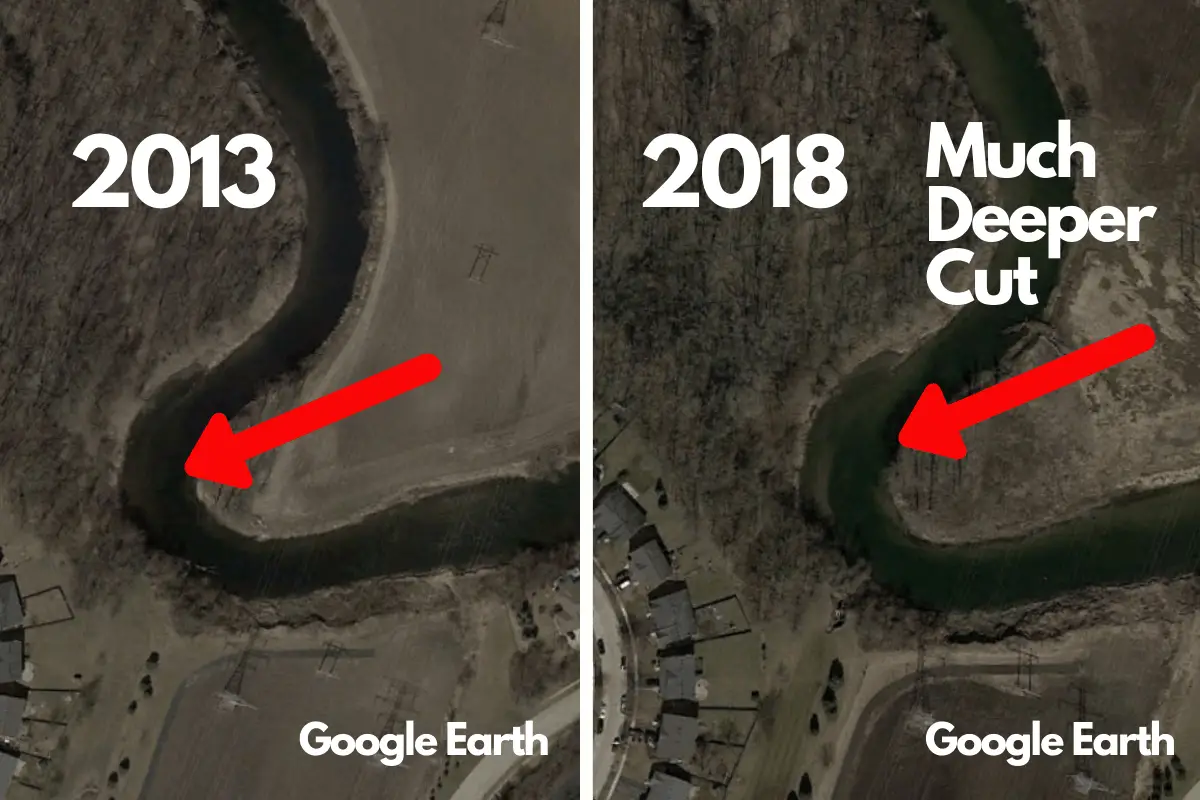
River Systems
This may be the most helpful aspect of Google Historical Imagery I ran across.
Bass anglers that apply their craft to river systems are fully aware that these waterways almost seem like a living and breathing creature.
They change and offer different variables all the time.
For those that have fished the same river system for years, shoreline erosion, construction, and other man-made variables can completely change the make-up and attitude of a fishery.
The Historical Imagery portion of Google Earth makes these changes crystal clear.
The formation of new holes and pockets created by the current and extreme floods may go unnoticed by anglers when fishing from a boat or the shore. A quick glance at the historical data can show new places where bass may hide and ideal wintering holes not previously known.
River systems are also more likely to have changes in shoreline composition where municipalities attempt to stop erosion.
The satellite images sometimes show where rip-rap has fallen farther into the river than originally thought. A single chuck of concrete on a bend can hold a number of smallmouth. Studying historical changes in the water can reveal these locations.
A Few Minutes Can Make a Difference
Spending a few minutes on the Historical Imagery section of Google Earth can possibly reveal some critical information.
Going from your computer desktop to holding a lunker bass on the very location you found is quite rewarding.
The Pros Know
Taking a quick glance at a professional angler’s boat tells us electronics are important. Many top anglers have more money in graphs than most of us could ever justify.
If you take a closer look at some of their boats, you will find mounts for Ipads near the console as well. These are used to scroll through Google Earth images while out on the water.
It can be that helpful of a tool.
Especially when traveling and studying locations for the first time.
Final Thoughts
It is fascinating to study our favorite lakes, ponds, and rivers from the air.
The change of perspective is informational and can be applied to our on-the-water experiences.
Using the Historical Imagery portion of Google Earth is a function that is worth a few minutes of investigation.
Who knows?
You may find a change that no other anglers have found.
Tight lines. Be safe and make sure to encourage someone today. You never know how you may change their life forever.
Isaiah 6:8
Recent Posts
There are few things that are more fun than watching a bass explode on a topwater lure. The wide diet of largemouth bass create lots of opportunities for anglers to mimic prey species. The Two...
Angler frustration can build when cast-after-cast is ruined by weeds and slime getting stuck on your lures. This reduces the amount of time your bait is working at its maximum efficiency and...